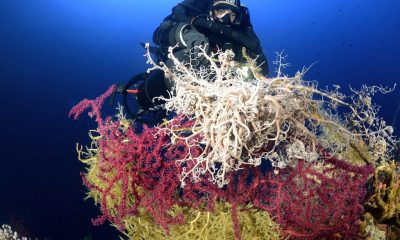
Cave
Mapping the Mine of Maria Concordia – My Journey into 3D
Polish cave diver and entrepreneur Marcin Stempniewicz, president of Submerged Foundation recounts his fascination with and journey into photogrammetry, and its application to dark, underground water-filled spaces. He explains how his team’s efforts led them to the 3D mapping of the Maria Concordia magnesite mine in Sobótka, Poland.
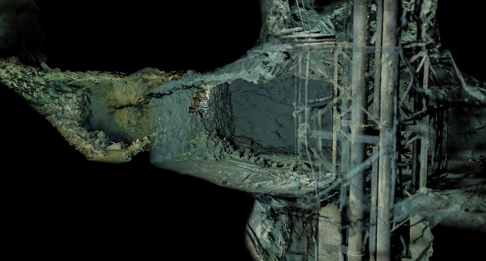
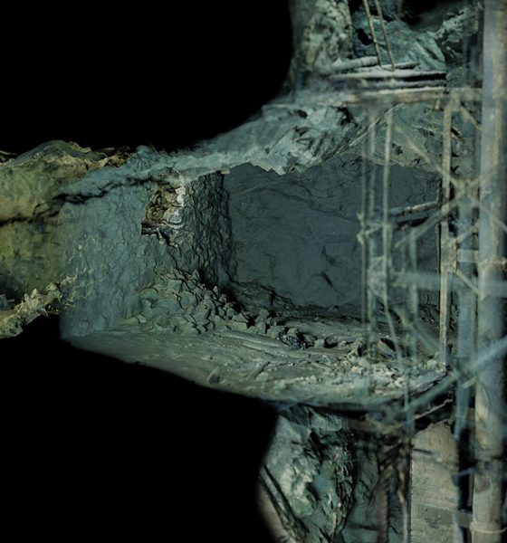
By Marcin Stempniewicz. Images courtesy of M. Stempniewicz. Lead image: cross section of the Maria Concordia mine.
Scanning In 1860-The Origins of 3D Image Capture and Printing
During the last board meeting of our Submerged Foundation, the word ‘scanning’ was mentioned 94 times. I counted. An outsider listening might think we are talking about incredibly technologically advanced endeavors. Scanning, photogrammetry, 3D printing … Difficult matters. But are you sure?
I decided to check the origins of what we call photogrammetric scanning today, i.e., creating a 3D solid based on photos of an object. My search took me back to 1860. A certain François Willème, a photographer and sculptor, had his atelier in Paris at that time. Like any sensible entrepreneur, he was looking for ways to reduce operating costs and increase the volume of services sold. Today we would say that he was trying to ‘scale the business’. But how do you scale making client busts? It would seem that this is an impossible task. Not for François. He stated that the most difficult thing in a sculptor’s work is to capture the resemblance to the model, while carving the details can be left to less experienced journeymen and students.
An innovative photographer decided to conduct an experiment. He placed cameras in a circular room, pointing at the central point where the model stood. By taking photos around the model, he obtained a set of outlines of the bust, each outline rotated by about 20 degrees relative to the previous one. Then, based on the outlines thus obtained, our author cut out profiles from thin pieces of wood, which constituted the skeleton of the sculpture. After filling the space between them with clay, he obtained a preliminary form, ready for further processing. In this way, the process of creating a sculpture would shorten from months to days, while laying the foundations for the concept of both scanning and 3D printing.
Photogrammetry Nowadays – More, Faster, Deeper
Today, photogrammetric scanning looks ‘slightly’ different, although the principle remains the same. We take a series of photos of an object from different perspectives, and specialized software finds common points in the photos and determines where these points are located in 3D space. And although the process takes a long time (calculations can take weeks for projects consisting of hundreds of thousands of photos), this time is shortening as the availability of faster and faster computers increases. Thanks to photogrammetry, we have the opportunity to transfer any object that we can photograph to the virtual world. Suffice it to say that this spring, a three-dimensional model of the RMS Titanic was published, created on the basis of a mere 700,000 photos.
I became interested in photogrammetry about five years ago. I was already a cave diver back then. I have always been fascinated by closed, difficult to access, dark and mysterious spaces. Combining cave exploration with diving quickly became a lifelong passion for me. Like every enthusiast, I could never refrain from talking to a larger group about my profession. And almost always the end was the same—polite nodding and complete lack of understanding in the eyes of the interlocutor.
Maybe I’m just not a wordsmith (quite possible). Or maybe it’s something more—levitating in a state close to weightlessness, surrounded by an irregular, fanciful shape that is difficult to describe, in complete darkness dispersed only by the light of a flashlight and with the awareness that I am in a crevice covered with hundreds of thousands of tons of rock is something that has its own meditative charm but difficult to describe to someone who has never gone underwater.
Even though I can count myself among the lucky ones who have discovered ‘their world’, there has always been something missing in this puzzle. It happens that I visit places so amazing, either in terms of rock formations (caves) or the history present in them (mines), that I instinctively want to preserve what I see and share what I saw. Underwater photography never fascinated me, but I was interested in underwater cartography. So when I found out that I was able to save the places I visited in the form of a 3D model—I knew that this was what I wanted to do.
Scanning Flooded Mines And Caves – Safety Considerations Vs. Documentation Value
I have already indicated my first reason for creating documentation of flooded underground corridors—popularization of these places, showing the beauty of cave diving. What about more practical applications? First, cartographic activities. Photogrammetry is one of many techniques that we can use to create a detailed map of an underground facility, be it a cave or a mine. I personally see more sense in scanning caves, the highly irregular shapes of which justify the use of a 3D scan.
Let us remember that photogrammetry is only a tool serving a specific purpose. When starting a demanding project of documenting underwater corridors, let’s always ask ourselves: ‘Why am I doing this’ and ‘what will I find there?’ It may turn out that our goal is to make a map, and our facility is a mine consisting of straight and long corridors of considerable length, e.g. over 10 km., let’s then abandon the idea of scanning and use traditional mapping techniques, i.e., a disto laser measure, a compass and an underwater notebook.
An astute reader might say, after all, we are talking about documentation of the mine using the photogrammetry method, and the author himself says that it is a bad idea?’ I hasten to answer that in some respects—yes, tragic. If, as indicated at the beginning, I intended to create a map only of corridors, I would follow my own advice and limit myself to writing down basic parameters such as azimuth, depth and length of each section.
However, this activity would have limited sense because, in the case of the Maria Concordia mine described here, a map of the most extensive corridor at a depth of 8 m/26 ft below the water level already exists and is easily accessible. The deeper levels are much less complicated.
So let’s move on to the second possible purpose of performing the scan: improving safety in tourist diving. One of the factors that significantly affects diving safety is the diver’s psychological comfort—in reasonable doses, of course—because in excess it can lead to unnecessary bravado. Diving in a new, unknown place is a stressful factor, even if we don’t want to admit it to ourselves. In such conditions, any failure under water, whether it is loss of visibility or a hardware problem that must be solved immediately, is another brick in the stress pyramid, where the current foundation is being in an unknown space.
Can getting acquainted with a three-dimensional model of the place where we will dive reduce this stress? And if so, to what extent? It is difficult to answer this question definitively, primarily because it is impossible to conduct a reliable study. Performing scans of significant parts of flooded caves and mines is a relatively new activity; you can count on one hand how many such objects in Europe have been documented in this way.
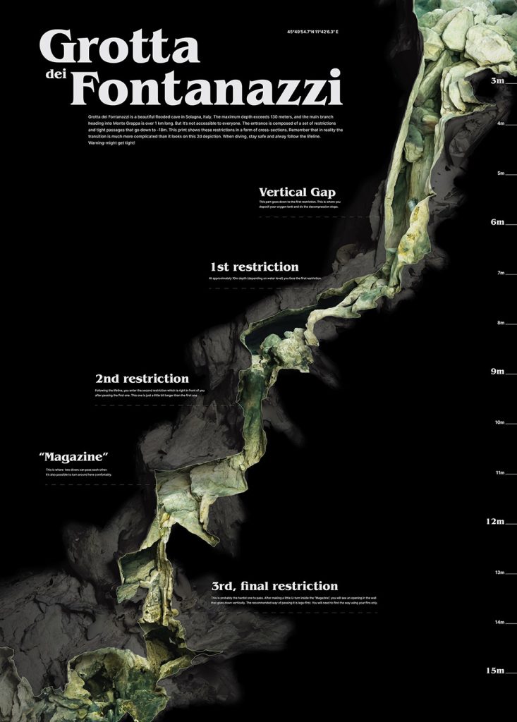
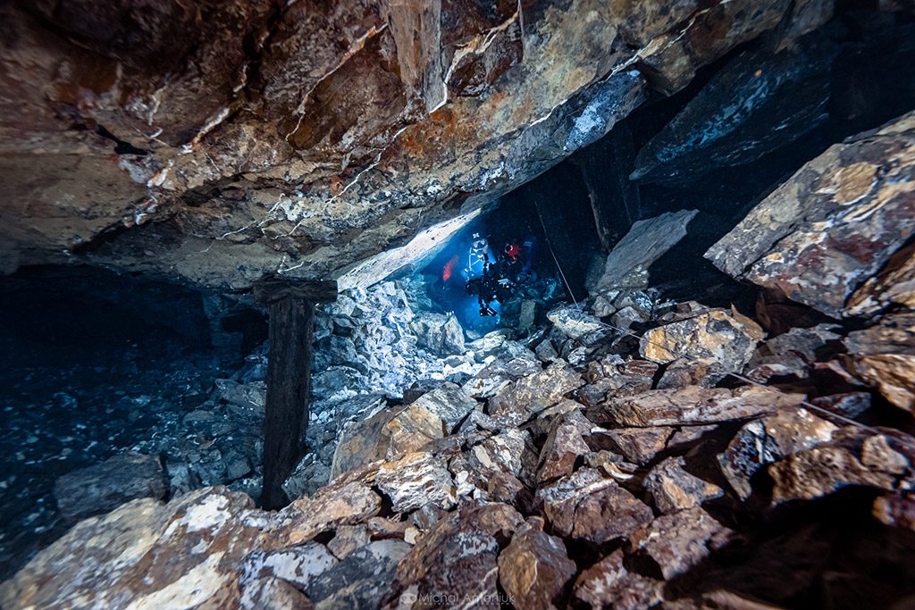
Several people with outstanding achievements in cave exploration cooperate with the Submerged foundation I run, including our compatriot Bartek Pitala. One day I saw Bartek’s scan of a rather complicated entrance to the Italian Fontanazzi cave. This cave is known for a series of restrictions protecting the entrances to further parts. After completing several virtual ‘dives’, I had no problems with navigation, so I can say that this type of familiarization with the place we intend to visit makes perfect sense and reduces at least one stress factor.
Following this line of thought, some time ago I talked to my friend Mikko Paasi from Finland, who was involved in the rescue operation in the Thai cave Tham Luang. He recalled a situation when, while evacuating boys trapped there, he and other participants had to squeeze through a rather narrow opening (well under a meter in diameter) with zero visibility! They had no choice because that was the way the handrail led them, i.e. the ropes showed the way to the exit. Only after the action, when the water had subsided, it turned out that the hole had the shape of a keyhole, it was enough to move the life line a by several dozen centimeters to the place where the hole widened to make it possible to swim through relatively comfortably—but no one knew about it at that time and in the absence of visibility any ‘experiments’ may end tragically.

When performing a scan for cartographic purposes or to improve the safety of divers, we assume that the environment does not change drastically in a short time. This is a safe assumption in the case of caves, where karst phenomena do occur and influence the shape of the corridors, but this process takes place over millions of years. However, there is an exception— glacial caves, which can radically change their shape within one year. In such an environment, performing digital documentation (scan) will be motivated in a completely different way. By creating successive scans over specific periods of time and comparing them, scientists are able to better understand the processes occurring in a given object.
The same applies to places or objects subject to degradation—e.g. wrecks, of which, according to various estimates, several thousand may exist in our Baltic Sea. Preparing 3D documentation of a given wreck over several years allows us to not only determine the rate of its degradation but the process also becomes a way to preserve cultural heritage. An example of such an undertaking is ‘The Thistlegorm Project’, which aims to document one of the most famous wrecks of the Red Sea.
The Human Factor – When the Operator Becomes a More Scarce Commodity than the Technology.
Once we know what we want to do and why, it’s time to take action. I do not use remotely operated underwater vehicles (ROV) in my projects. I make the scans myself, together with divers cooperating with the Submerged Foundation. Perhaps this will change in the future, but for now this form of activity is completely sufficient for us.
It is worth taking a look at what diving in caves and mines actually is and how it differs from recreational diving. It’s likely that all of your readers have had experience with recreational diving in so-called open water.
We see the first difference immediately. Cave diving, more commonly known as overhead diving, excludes access to the water surface. Every problem that occurs underwater must be solved underwater. The assumption that ‘I will emerge if necessary’ is out of the question. When diving in caves and mines, there are situations when the nearest exit from the water is several hundred meters away. If we use underwater scooters, this distance can be counted in kilometers.
As you can easily imagine, this state of affairs imposes a different dive plan. First of all, each piece of equipment is duplicated. Two independent breathing gas cylinders (breathing mixtures in technical diving are a topic for a separate article) is the absolute minimum. For my dives, I usually use three or four tanks. In addition, two sources of buoyancy are necessary.
It’s not a surprise to anyone that it can be dark in a cave. That’s why I take the issue of lights seriously. The procedures state that a minimum of three light sources is required. If the first one fails, we turn back—this way we are left with one spare light, not yet used, for the return journey. I usually have four or more lights on my dives. This is why loss of visibility due to light loss is relatively unlikely.
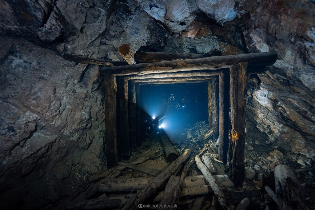
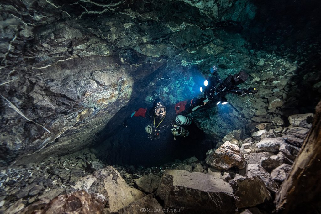
A much greater threat (which I have experienced many times) is the decrease in visibility resulting from the sediment rising from the bottom. If it happens that the sediment rises as a result of, for example, touching the bottom, then it is the fault of a careless diver. However, there are places, such as the Maria Concordia mine described here, where the sediment is so fine that it can be stirred up not by touch, but by the movement of water resulting from the presence of a diver.
It is practically impossible to move in tight tunnels, of which there are many in Lower Silesia, without touching the walls. Let’s also remember about bubbles from the regulators, which reduce visibility by stirring up the particles from the walls and ceiling. In other words, a cave diver must be prepared to cover the return route in zero visibility. Instructors (the better ones, anyway) preparing students to obtain full-cave qualifications enforce this skill with full severity, forcing students to dive blindfolded, sometimes using additional difficulties, such as unexpectedly closing the valve of one or both cylinders.
In my case, the path from a recreational diver to a technical diver with full cave qualifications took about five years. In my opinion, this is the right time to feel comfortable in the water for someone who does not dive professionally. The time from obtaining caving qualifications to my first mine scanning projects was another 3 years. And again, I’m glad I gave myself this time, because scanning the cave is an activity that one needs focus for. Operating equipment, checking the gas pressure, adjusting buoyancy, are things that should be done automatically.
Scanning In The ‘overhead’ Space – First Attempts
But what exactly is this scanning that requires so much concentration? Let’s repeat—photogrammetry is a technique that aims to obtain a 3D model based on photos of a specific object from various angles. So my goal during a documentation dive is to take photos of every part of the wall, ceiling, and floor in several shots. This is something that cannot be done without working systematically. Let’s imagine a corridor 1 km long. How do I know if I have already photographed a given place? What is needed is systematics and a specific course of action.
I developed my way of taking photos during my first project, scanning the Marie Agnes adit in Bystrzyca in Lower Silesia, Poland. This silver mine seemed like the perfect place to conduct tests. The compact shape and relatively short corridors in the flooded parts (less than 100 m/328 ft in total) gave hope for relatively quick results and the opportunity to test various techniques.
The first ‘discovery’ was that the way of holding the camera as in underwater photography (i.e. the camera held in your hands, in front of you) does not work at all. Taking photos around the cross-section of the corridor with the camera held this way was—to put it mildly—uncomfortable. So I used a 1.5 m long boom, at the end of which I attached a GoPro camera and a single wide-angle video light. I balanced the whole thing using Styrofoam so that the entire set was neutrally buoyant underwater (i.e. colloquially—it weighed nothing). It was a bull’s-eye.
Without making any movements, I could make a full circle corresponding to the cross-section of the corridor, with the camera always directed perpendicular to the photographed part of the wall. Another benefit resulted from the specificity of diving; the Marie Agnes tunnel is one where visibility drops very quickly and tight corridors force you to come into contact with the walls. By holding my set up in front of me, I gained visibility because the camera was in less murky water ahead of me.
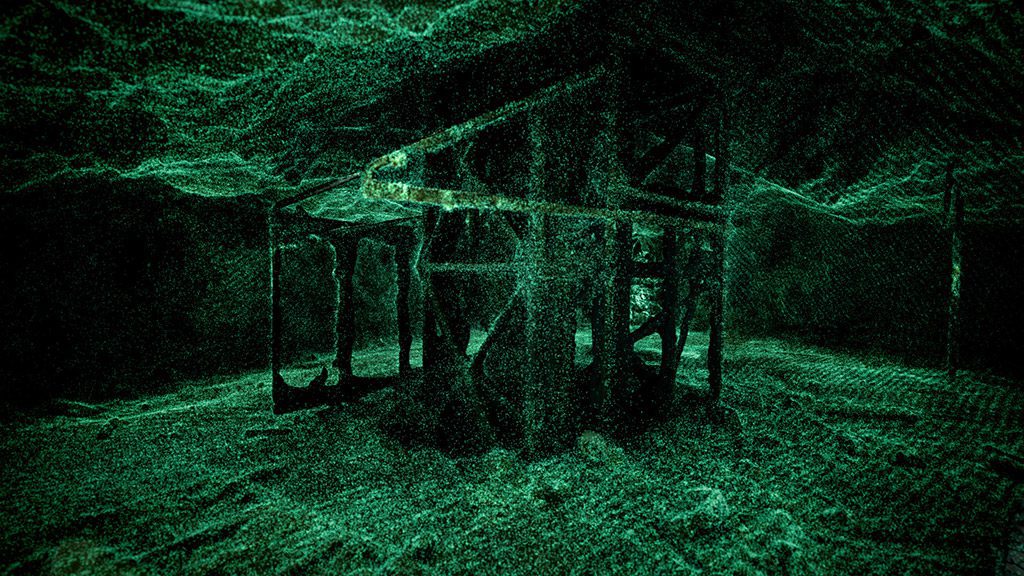
The result of the work turned out to be more than satisfactory. I created a detailed 3D model of the flooded mine levels. By ‘detailed’ I mean one where you can clearly see every stone. I spent a few pleasant weeks making visualizations showing how beautiful this place is. I also published a map with descriptions of individual elements, such as a wooden pipeline, a winch for extracting the excavated material and wooden structures supporting miners’ ladders. I finished the project by publishing a 3D model of the mine on the Sketchfab platform.
On to the Maria Concordia Project
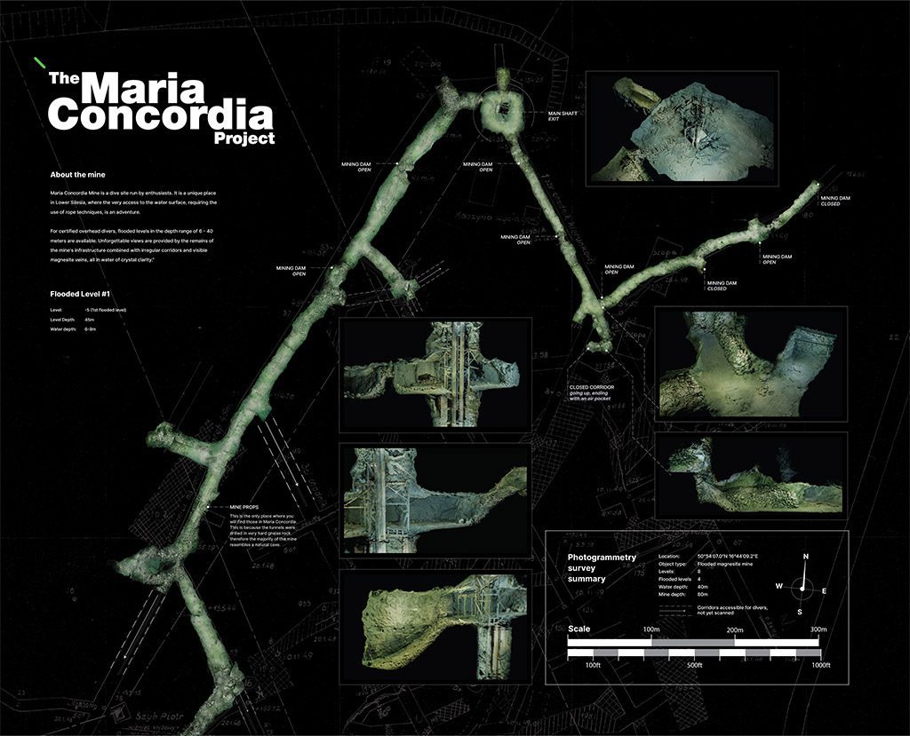
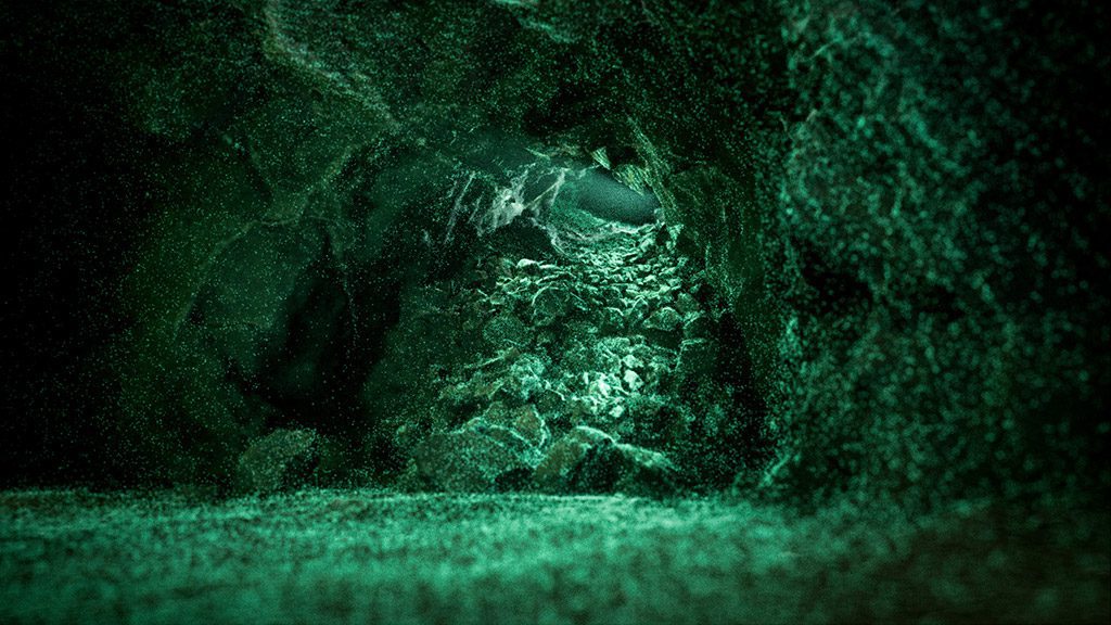
Everything indicated that it was time for a more ambitious undertaking. The Maria Concordia magnesite mine in Sobótka, Poland in the Lower Silesia region was an obvious choice. Crystal clear water, beautifully visible magnesite veins visible on the walls, interesting remains of mining infrastructure and a relatively small depth (max. Approximately 40m)—all this made us choose this facility. The length of the flooded corridors, which we initially estimated as about 1.5 km (in practice, after taking into account all the side corridors, it turned out to be slightly longer) also seemed to be a challenge on the one hand, and something that ‘can be done’ on the other.
It was obvious to me that this was not a one-person project. We managed to gather a great team relatively quickly—four cave divers (Bartek Kamiński, Michał Antoniuk, Mikko Paasi from Bottomline Projects and me), two people providing surface support (Mateusz Zahora from the Submerged Foundation and Kamil Porembiński from ‘Spodwody’ podcast) and two people supporting us technically in the field of photogrammetry and 3D graphics (Mariusz Milka from the Submerged Foundation and Bartek Przybylski). I knew it had to be a success with such a team.
We also managed to get some great support from XDEEP and OrcaTorch Poland when it came to the gear. However, the closer the day of the first dives approached, the more doubts I had during the first attempt. We had only two and a half days for diving (which was still a success, considering that each of us had to more or less adapt to the rest in terms of time, holidays etc.). Our assumption was that the team of divers work would overlap.
After each dive, the surface team took over the scanning equipment from the diver, replaced the batteries in lights and cameras, downloaded data from memory cards to a disk, equipped the whole unit with new batteries and handed it to the next diver, already waiting in the water. During this time, the first diver would take off their equipment and rest. The surface team’s second task was to charge the batteries—it sounds trivial, but considering that there were 48 flashlight batteries and 15 camera batteries in use—it required some concentration. This amount resulted from the hardware configuration used.
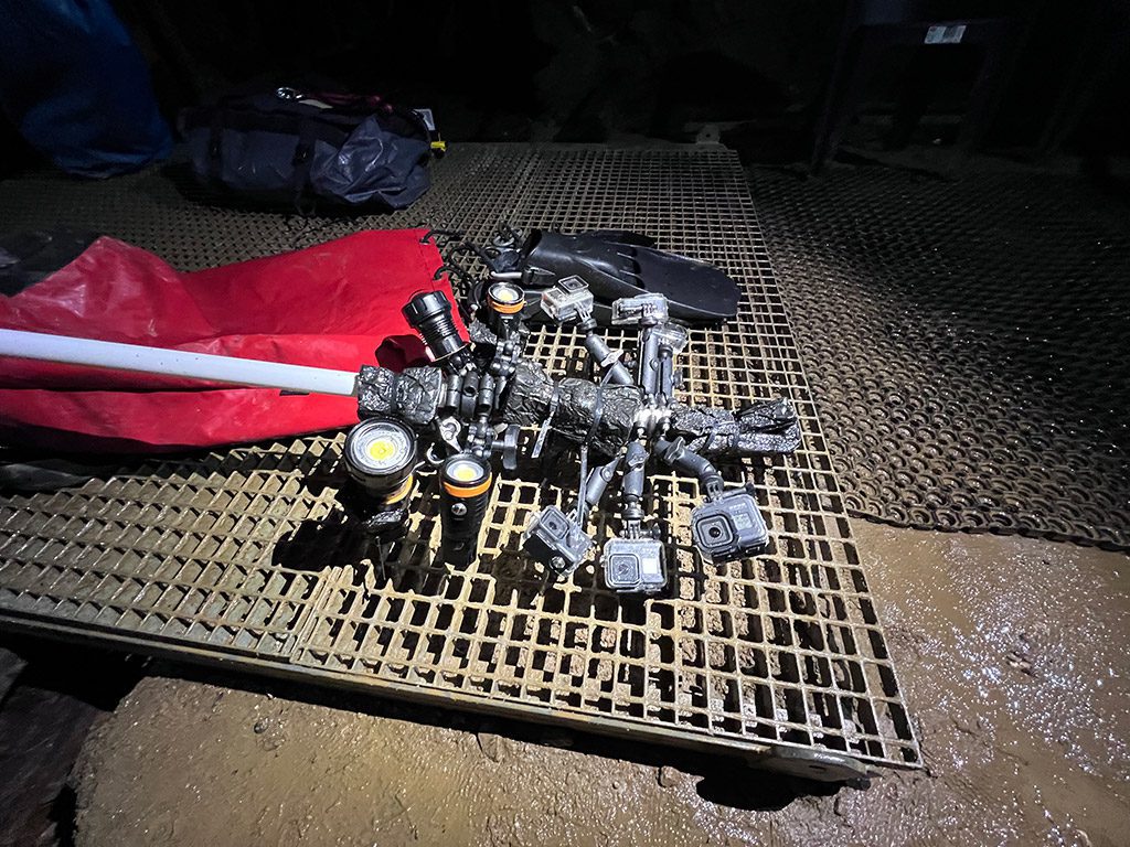
While in the case of my first project I used one GoPro camera and one flashlight, in the case of the flooded corridors of the Maria Concordia mine, it was necessary to ensure faster data acquisition. After conducting several experiments, we decided to use five GoPro cameras mounted on a boom so that the field of view of each camera would overlap by approximately 50% with the field of view of the next camera. In this way, during one one-second interval, our set took photos of approximately half of the corridor cross-section.
For lighting, we used four wide-angle video flashlights (each used four batteries). We assumed that for continuous operation we would need three sets of batteries for both cameras and flashlights. I knew that this way we would be able to make six dives a day, but to achieve this—everything had to run like clockwork.
This is where learning from the cave diving course turned out to be useful—always have a plan B. And, preferably, C and D. A few days before leaving for the mine, it turned out that Michał, one of the divers, was ill. It was a big blow, because Michał is a professional underwater photographer. Unlike the rest of the divers, he was not supposed to perform a scan, but to document our struggles with his lens.
Ok, it is what it is. I knew that it would not end with one trip anyway; we would do an underwater photo session another time. In the meantime another issue presented itself. Out of spite, several memory cards—as if on command—refused to cooperate. And how can you not believe in the malice of inanimate things? Fortunately, one of the divers, Bartek, was still on his way and filled the gaps in the electronics store.
Executing our Plan
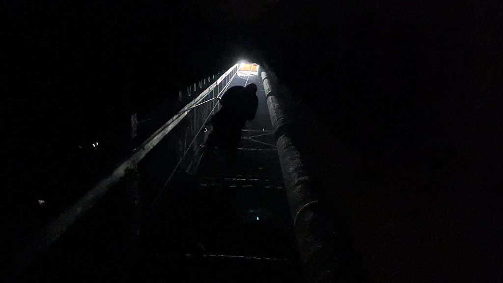
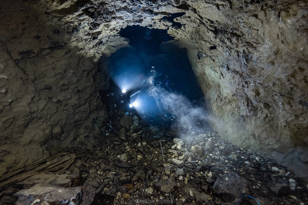
The time had come to divide into teams—surface and underground. I deliberately used the word ‘underground’ and not ‘underwater’. Maria Concordia is a mine that is only flooded to a certain level. To get to the water, you need to lower yourself approximately 40 m/121 ft into the shaft using an electric winch (supervised by the owner of the facility and his team). The journey down is amazing. As we descended, hanging in the dark shaft, we passed the entrances to subsequent dry levels. At the bottom, we were greeted by an illuminated chamber, prepared for the needs of divers, where we geared up on a steel platform placed at the water level. While the journey down was quite an adventure itself, it did involve some logistical difficulties.
The air humidity in the ‘dry’ chamber is so high that we did not want to replace batteries in cameras and flashlights there. While nothing bad would probably happen to the equipment, there is too great a risk that moisture that gets into the waterproof GoPro cases will cause cold water to condense and the case will fog up from the inside. Therefore, after each dive, the entire set of cameras and lights must go up, where the surface team replaced the batteries and copied the data to the hard drive.
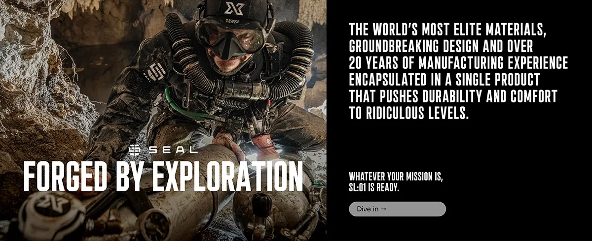
The first dives were a bit chaotic. Bad luck still haunted us, because already during their first dives, Bartek and Mikko noticed leaks in their suits. Water at a temperature of 8 degrees Celsius, even with a small leak, can quickly cause the body to cool down, not to mention extreme discomfort. Fortunately, we were prepared here too—the spare suits (including brand new Seal drysuit) passed the test.
With each subsequent dive we became better organized. Already on the second day of our operation, everything went smoothly—the briefing, checking on the working map which parts were scanned during the previous dives, the subsequent battery replacement—everything worked smoothly, and each of us knew what to do. Finally our trip came to an end. We took about 110,000 photos on all 4 levels, but we knew that the shallowest and most extensive level would require at least two more visits to the mine.
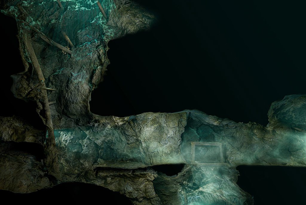
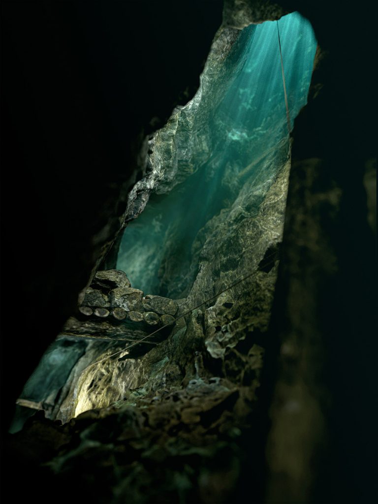
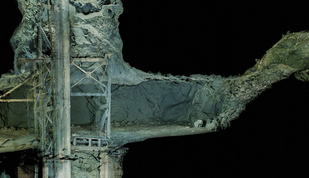
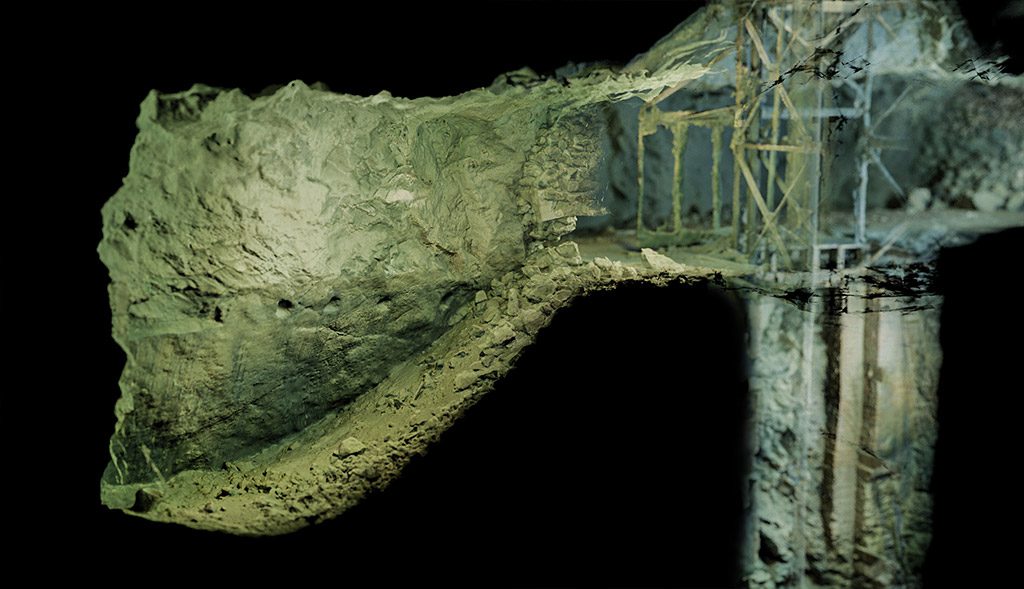
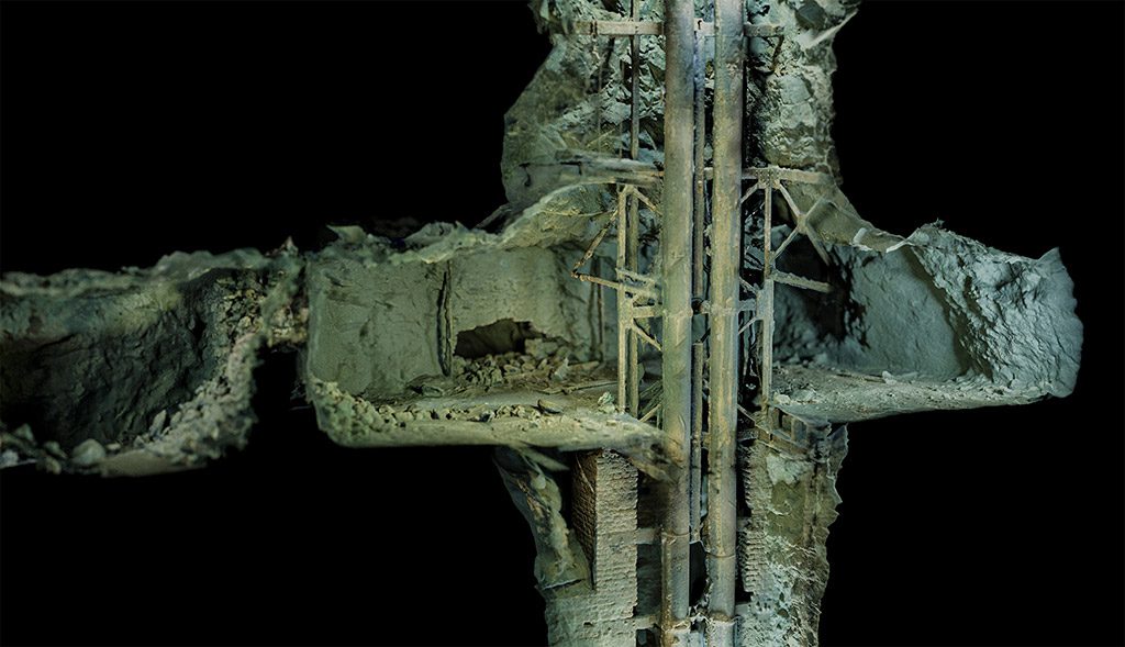
Then it was time to digitally process the acquired material. I will not bore the reader with technical details—let the fact that the processing of the material took well over a month speak for itself. Once the 3D models of the individual levels were created, it was time for some creative work. I was wondering how to show a 3D model of a given level so that it was visually attractive and carried a story. The cross-sections turned out to be the most promising.
In addition to simple corridors, the mine has several spectacular-looking places, such as the main shaft. Thanks to the cross-sections, we managed to not only to show details, such as magnesite veins visible on the walls or the remains of scaffolding and mining equipment, we also managed to do something more (and quite by accident). We have developed a visual style that, so far, is characteristic only of the documentation conducted by the Submerged Foundation.
In addition to static visualizations, we have experimented with ‘virtual diving’ animations as well as VR and AR solutions. The project is still ongoing, so we haven’t said the last word yet. You can follow the project’s progress on the Foundation’s website Submerged Foundation, and on the project website The Maria Concordia Project.
A Map That Anyone Can Make, Including You.
Everything I described above may seem complicated. But this does not mean that 3D scanning is available only to a select few. On the contrary. What fascinated me about photogrammetry was the availability of this technology. Do you want to make your own scan? You don’t need expensive equipment for this. All you need is a phone to take photos. Software is not a problem either, as open source solutions are available. Of course, a fast computer will be useful, but it’s only a matter of how much time you can devote to waiting for the results.
The issue of scanning the underground is a bit different—here, the necessary equipment includes a decent flashlight. And while I absolutely advise against any activities under water if you do not have the necessary qualifications (you will definitely not achieve any results and you will most likely hurt yourself), I strongly encourage you to try it yourself in dry underground—caves, bunkers and other such facilities.
Do You Want To Teach History? Tell Me A Story.
So far, we have taken approximately 160,000 photos in the Maria Concordia mine. Is that a lot or a little? You’ll probably say with a slight hesitation and a shrug of your shoulders that it’s a lot. Let’s try it differently. The recently published scan of the Titanic wreck was based on 700,000 photos. This means that our scan is one-fifth the complexity of the Titanic. This is, of course, a gross oversimplification, because the Titanic lies 100 times deeper. As for the costs of the operation, I suspect that the Titanic cost at least 1,000 times more (although this is unverified information).
Already know what I’m talking about? Our brain works in a certain way—it absorbs information better if we show the context. Documentary film directors know this, for good documentaries show a specific story, not dry facts. It was the same thing here. I knew from the beginning that creating a 3D model of the mine was not enough to interest the audience. Only presenting it in the form of cross-sections, animations, plans, etc. allowed us to interest a wider group—both divers and enthusiasts of history and speleology. That’s why I always treat going underwater with a camera and then making a model as just the beginning of the adventure. For me, a scan is a tool I use to tell a story.
At the beginning, I mentioned that cave diving is an activity whose charms are difficult to convey to people outside the inner circle of its enthusiasts. We can also extend this to any type of passion—mountain climbing, sailing, paragliding—and even atomic physics. Not everyone is interested in these activities and not everyone wants to hear about them. But each of them can create exciting stories. Yes, even about atomic physics. You don’t believe it? Just go and watch the movie “Oppenheimer”. You’ll love it.
| Divers: Michał Antoniuk Bartek Kamiński Mikko Paasi Marcin Stempniewicz | Surface support Mateusz Zahora Kamil Porembiński | 3d reconstruction process Mariusz Milka Mateusz Zahora Marcin Stempniewicz |
| Photogrammetry-based maps Marcin Stempniewicz | Supporters XDEEP Exploration Support Program OrcaTorch Poland Divers24.com Spodwody podcast |
DIVE DEEPER
Submerged Foundation: The Maria Concordia Project
InDEPTH: A First Exploration of the Flooded Mines of Thailand by Mikko Paasi
InDEPTH: They Discovered an 11,000-year-old Submerged Ochre Mine by John Kendall
InDEPTH: Out of the Depths: The Story of British Mine Diving by Jon Glanfield
InDEPTH: I See A Darkness: A Descent Into Germany’s Felicitas Mine by Andrea Murdock Alpini.
InDEPTH: Mine Over Monitor: Iconic dive sites with a shared history by Edd Stockdale
InDEPTH: The Life & Times of a West Coast Photogrammetrist: Could it be the Almirante Barroso? by Kees Beemster Leverenz
InDEPTH: Adventures in Picture Making by Kees Beemster Leverenz
Marcin Stempniewicz is an entrepreneur and cave diver. He is also the president of the Submerged Foundation, an organization engaged in the exploration and documentation of underwater caves and mines using 3D scanning techniques. In addition to hard-to-reach overhead objects, our projects also include documentation of Baltic Sea wrecks and documentation and archaeological work on monuments from the times of Ancient Rome—both on land and underwater. For more details, please visit Submerged Foundation.
CAVE-PRINTS
Discover the world of diving, history and science. At Cave-prints.com, we bring the beauty of the dangerous world of overhead diving right to your walls. Our mission is to share the passion for history, cartography and underwater exploration. Explore our collection of premium-quality posters that includes both underwater cartography prints created in collaboration with the Submerged Foundation and some stunning cave-diving photographs! Oh, you’re still reading? Wow! Let’s reward your perseverance. During the checkout, just enter the code “I actually read that” and get your 20% discount! Visit Cave-Prints.com
SUBMERGED FOUNDATION
Our organization is dedicated to the preservation, exploration, and documentation of underwater wrecks and caves through the use of photogrammetry. Our mission is to contribute to the understanding of maritime history and to protect the natural underwater environment.
We believe that the preservation and documentation of these underwater sites are crucial for future generations to learn from and appreciate the history and culture that they represent. With the use of cutting-edge technology and techniques, we aim to create accurate 3D models of these sites that can be used for research, education, and preservation purposes. Visit SubmergedFoundation.org


Dial In Your DCS Risk with the Thalmann Algorithm

Deep Tunnel Workers Go Trimix

La Grande Dérive

California Dreamin’

British Invasion—Thailand Karst Edition 2024

Harnessing the Power of ‘Educated’ AI to Improve Diving Safety