Technology
Navigation, Connectivity, Control: Forging the Next Chapter of Dive Technology
From jury-rigged sonar boxes to Garmin’s sleek new S1 buoy, underwater navigation has come a long way. Gabriel Pineda asks: is this the breakthrough divers have been waiting for?
By Gabriel Pineda

I See the Future
On July 3, 2024 InDepth Magazine published an article I wrote. It seems that in said article I predicted the creation of the Garmin S1 Buoy. I was even told that my article could have compelled Garmin to create the S1. As much as I’d love to have such foresight powers and compelling writing skills, the truth is different. In reality Garmin started working on sonar modems as far back as 2015.
Ten years ago, their Cary, NC, R&D team developed an underwater sonar modem. It was initially a Pelican case with three transducers for triangulation and underwater positioning, plus GPS antennas. The vision was to bring GPS functionality to underwater environments. I roughly explained the concepts behind this approach in another article I wrote in 2023.
Based on this timeline, Garmin already had underwater connectivity and data networks in mind when they officially made the incursion into the dive community eight years ago with the launch of the Descent Mk1. The use of sonar links with the Descent Mk2i was an inkling, but it was not strictly new to the civilian, sports diving market. Back in 2013, Liquivision offered its Lynx model with similar wireless features to those touted by the Mk2i.


To me, the more definitive telltale sign was the launch of the Descent Mk3 with its T2 transceiver. Adam Demicco, Garmin’s Dive Engineering Manager, confirmed that several people approached Garmin asking about any upcoming topside GPS functionality to pair up with the Mk3/T2 transceiving capabilities. So no, I’m not that special. There are others who see the future as well. Though none others published their visions of the future in InDEPTH Magazine. I guess I am a little bit special .
This is pretty exciting news. We will now, as civilian sport divers, finally have access to the elusive underwater GPS. In this article I’ll tell you about my impressions during the two dives I did with and without it in Cary, NC. I will also go into what I think might be coming down the product roadmap pipeline. I will even give you some tips to get intel out of manufacturers and how to get them to implement the features you want. But before we go into those details, let’s review what’s happening in the world around underwater data networks and other advancements.

Wireless Rebreather Electronics
In my previous article, I mentioned the Symbios eCCR and its plans for wireless handsets. Until recently, details about the wireless technology behind these handsets were scarce. Wireless rebreather handsets are understandably a delicate topic. Over the years, I’ve often been asked why we don’t yet have reliable wireless pO₂ transmission in rebreathers, despite the wider acceptance of wireless tank pressure transmitters.
To answer that, let’s revisit the adoption curve for wireless pressure transmitters. These devices weren’t always embraced, especially by the tech diving community. For years, brass and glass gauges were the gold standard, seen as more reliable than transmitters that were prone to communication dropouts. As some of the reliability issues were addressed, the advantages of having pressure transmitters over brass and glass gauges became more visible. And the community went from avoiding, to tolerating, and eventually to hearing some credible, respected voices that went as far as to recommend the use of wireless pressure transmitters citing very good reasons.
However, the criticality of continuous, accurate pO₂ monitoring isn’t the same as knowing your tank pressure. In closed-circuit rebreathers (CCRs), your gas supply often isn’t the primary limiting factor. Even when diving open circuit, experienced divers will use tank pressure information to double check that their carefully laid out gas plan is still on track. Under normal circumstances, a tank pressure check is just meant to confirm information that you already knew with reasonable accuracy.

Awareness of your pO2 is fundamentally different. Hypoxia or hyperoxia can happen quickly and with little or no warning signs. Their consequences can easily be fatal. Systems reporting pO₂ must be reliable and continuous; losing that data, even briefly, is unacceptable. Unlike tank pressures, you cannot afford to lose track of your pO2 even for a few minutes.
Because of this and until now, I would typically answer that wired handsets were a necessity. Also because of this, I found it fascinating that so many rebreather manufacturers manifested interest in the upcoming wireless rebreather controls. The new wireless handsets and its implementation has to present significant advantages over typical tech used for wireless underwater data communications. So let’s look at what makes it so special.
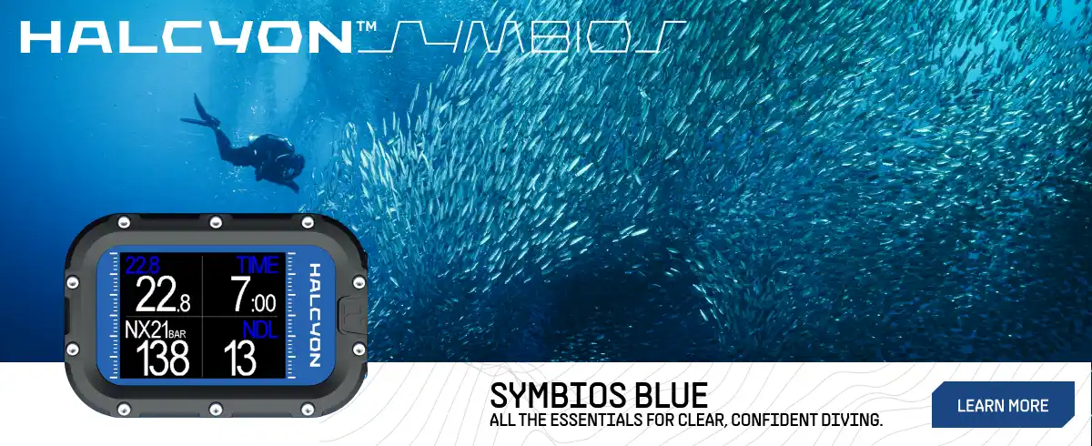
Magnetic Induction: The Future is Field-Based
One promising technology rising to meet these demanding reliability and safety requirements is magnetic induction communication, a method that offers unique advantages in low-latency, orientation-resilient, and interference-resistant data transmission beneath the waves.
On August 6th, Halcyon unveiled a wireless magnetic induction (MI) ecosystem for data communications in rebreather systems. The authors pointed out that this technology has existed for decades in the civilian underwater sport diving realm. So what makes MI all of a sudden worthy of handling the crucial task of reliably reporting pO2 readings? The announcement goes on to explain that in MI systems the dreaded communications drop can happen if the antenna coils get oriented to 90 degrees of each other. Halcyon addresses this by a dual axis antenna strategy, basically orienting two transmitting antennas in the CCR head at 90 degrees to each other. Handsets also have two receiving antennas at 90 degrees from each other. This drastically reduces the chance of all signals notching into 90 degrees of all antennas with a consequent reduction of signal dropouts.
“If 2 are Better than 1, are 3 Better than 2…?“
The case for advantages of dual-axis wireless MI over single-axis seems logical. However, you don’t have to dig very deep to find publications about the reliability of tri-axis MI coils. Wouldn’t rebreather divers want the maximum reliability possible? Not necessarily, tri-axis coils deliver rock-solid, orientation-independent communication. These are ideal for robotic swarms or dynamic environments but heavy on power. Meanwhile, Halcyon’s dual-axis MI approach achieves a smarter balance: enough redundancy to stay reliable in practice, while trimming hardware, and energy overhead, perfect for compact, life-support systems in rebreathers. You also have to take into account that having two independent transmitting antennas paired with two independent receiving antennas achieves the same result as having one transmitter antenna paired up with a tri-axis receiving antenna.
Another advantage of the dual transmitter approach is the redundancy that comes with pairing each of these with independent microcontrollers. One can fail and the other will still transmit data. A final failsafe measure comes from a vibration motor in the head. The user will receive a haptic alarm from the head if the pO2 gets to be less than 0.4 or more than 1.6. This haptic alarm is totally independent of the MI system; it should work even if the magnetic transmission is completely disturbed.

However, MI isn’t universally safe underwater, especially around magnetic mines. These devices are triggered by changes in magnetic fields, and even modest magnetic emissions from MI could pose a detonation risk. Clearance divers rely on non-magnetic approaches to minimize their signature. For explosive ordinance disposal (EOD) operations in mine-infested waters, neutral or non-magnetic communication systems remain the safer, preferred choice.
Halcyon’s new wireless approach is an exciting advancement in rebreather technology. This, coupled with their optical O2 sensors, points to exciting, positive changes in the way that we dive.
S1 Impressions
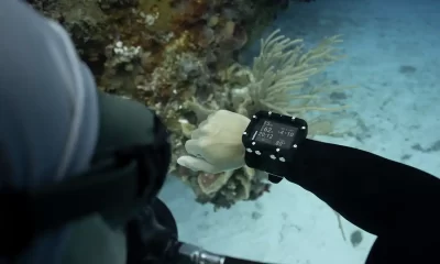
One of my first impressions was the persistence of the connection. Prior to diving with the S1, my experience had been with systems that have a range of 1km or more. I was concerned about the 100 m/328 ft specified range for the S1. Would this mean frequently dropped connections?

Fish finder sonars are often described as having a conical geometry to its coverage where the vertex of the cone is at the transducer attached to the boat. The geometry of the S1 is more of a hemisphere whose radius is nominally 100 m long. This is a loose geometrical oversimplification, but the point to illustrate is that if a diver vertically descends to 50 m/164 ft straight under the S1, said diver will only be able to traverse 87 m/285 ft horizontally at that depth before they get out of the nominal range.


With that in mind, on the day of the dive, I tried to break connections. I went inside a sunken bus and a sunken airplane looking to break line of sight with the buoy. I was only partially successful. I was able to break the connection, but the X50i kept on showing the last known direction to the buoy and was giving me a distance to it. So I wasn’t really lost or without any guidance; all I had to do was to get out of the airplane (the line of sight obstacle) and start swimming toward the last known direction. This is confirmed by the decreasing distance to buoy numbers. The full signal was promptly recovered.
Jessi Pooni, from Garmin, was telling us that even though the nominal range is 100 m/330 ft, when testing the S1, she’s gotten distance readings of 150 m/500 ft. Ben Collins, Garmin’s Dive Product Manager, further clarified that directional triangulation will be lost first, at around 100 m, however distance data is still available beyond those ranges. We are used to thinking that a lost signal means loss of all functionality. But, in this case, the real practical implications are more benign. Once we cross the threshold beyond that 100 m radius, it is likely that we keep on getting useful information to find our way back to the buoy or, at a minimum, to head back into range of the full coverage hemisphere. All that said, it will be prudent to plan dives taking only the 100 m range into account.
Another positive impression was the favourable ergonomics of this package. The buoy itself is no more cumbersome than the regular dive flag float that is often required in places like Maui. The S1 accommodates attachment points to tether dive flags like this. In my 2023 article about underwater navigation technology I mention practical ergonomics as a barrier to entry into the sports diving market. The S1 effectively addresses my concerns about ergonomics.
Antidote Against Premature Discontinuity
You may or may not remember that a few years ago, Garmin’s offering included an action camera, reminiscent of a GoPro. This camera is now discontinued.

So what will keep the S1 from the path to discontinuity? I was fortunate enough to share an Uber to the airport with Patrick Danko from Garmin. We had just finished a visit to the impressive hyperbaric facilities at the Duke University Hospital. I took advantage of the opportunity to ask Patrick what success looks like for the S1. What will keep it away from the path that the action camera ended up at?
Patrick mentioned that their incursion on the action camera market came at a moment when this was fairly saturated with dominant players leading in market share. He then explained that Garmin ideally prefers to open up new market spaces and differentiate. Patrick’s words sounded very similar to the principles described in the book, Blue Ocean Strategy by Chan Kim and Renée Mauborgne.
According to the book’s website, “Red Oceans are all the industries in existence today – the known market space. In red oceans, industry boundaries are defined and accepted, and the competitive rules of the game are known.
“Here, companies try to outperform their rivals to grab a greater share of existing demand. As the market space gets crowded, profits and growth are reduced. Products become commodities, leading to cutthroat or ‘bloody’ competition.” This is the scenario where Garmin’s action camera had to perform.”

The book’s website goes on to say, “Blue Oceans, in contrast, denote all the industries not in existence today – the unknown market space, untainted by competition. In blue oceans, demand is created rather than fought over. There is ample opportunity for growth that is both profitable and rapid. In blue oceans, competition is irrelevant because the rules of the game are waiting to be set. A blue ocean is an analogy to describe the wider, deeper potential to be found in unexplored market space. A blue ocean is vast, deep, and powerful in terms of profitable growth.” This is the scenario where the S1 buoy fits.
But this doesn’t necessarily mean that sport divers will massively flock to buy the S1. In fact, it could be argued that sport divers have been operating and navigating just fine with the tools currently available. And when you start diving deeper into the feature set currently offered, some may say it is somewhat underwhelming. There are no underwater maps where you overlay your position in real time, the range at 100 m seems low, and it is limited to working only with the Mk3 and the X50i (the Mk2 can also work in receiving mode only). For now, this is the current reality.


Is there any potential?
Plenty. Let’s start with the current feature set. The Mk3 introduced diver-to-diver messaging. With the S1, the messaging range gets extended to encompass the hemispherical coverage area we previously talked about. Additionally, divers can also communicate with the topside crew and vice versa. The crew is no longer limited to banging a metal ladder to recall divers to the boat. More than that, the crew will be able to see the location, depth and gas supplies of divers. These are all features that enhance the situational awareness of the entire dive team, topside and underwater. As such, the safety benefits are undeniable. At the end of a previous article, I write about a case study where I was remotely recalled back to the boat when an unexpected squall was coming upon the dive boat. As nice as it was, the equipment I was using at that time was not meant for sport divers for a variety of reasons, including price point and ergonomics. The S1 makes these features available to civilian sport divers.
But to me, the most exciting potential lies in what can be built upon this foundation. This is the very first generation of the S1. It is the foundation for more to come. Many of the improvements would only need software changes keeping the existing hardware. Let’s pick on two of the features mentioned in a previous paragraph:
- Underwater maps: Garmin could deploy underwater map overlays for their dive computers where the diver can see their position in real time and in relation to topographical features and/or a target for exploration marked as a GPS point-of-interest (POI).
Case usage: My son wanted to do a dive to see a couple of 1955 MkIII folding pontoon bridge boats left by the Royal Canadian School of Military Engineering in Cultus Lake, BC.
My friend Dale Carlisle discovered this some time ago. Another friend, John Campbell, placed a cave diving line, with cookies, making it easy for divers to find the boats. So, I took my son to what I consider to be a fairly easy dive—one I had done many times—but that was new to him. To my surprise, John’s line to the wreck was no longer where I expected to find it. We did find a line, but it ended in a small anchor. So the dive ended with no boats.
Using Google maps, I place the location of the boats near these coordinates: 49.054308, -121.973138. In an ideal world, I would enter these coordinates into the dive computer as a target. I would get to those coordinates using S1 buoy guidance and start a search pattern around it. Once I found the boats, I would mark the new coordinates in my dive computer. I would then share these with my friends and then we would be able to get back to the boats without a cave line.

I’ve had conversations about similar usage that can be applied to citizen scientist projects like the Sixgill Sharks of Seattle. In a project like this, we could cross reference time stamps of camera footage with the time stamp of the locations points in the dive heat map. This would give us accurate coordinates of our interactions with the sixgill sharks.
- Limited range: What if several S1 buoys could be linked up together to provide increased coverage? Prior to our visit to the Garmin facilities in Cary, NC, we were asked to provide questions or topics for the Garmin team to expand upon. During one of the presentations, Patrick Danko mentioned that the topic of networking multiple S1 buoys to increase range and coverage was one of the most popular ones. While the Garmin team was careful not to promise or pre-announce that this is coming up, it was also clear that they did not consider this a technical impossibility. Imagine if we could deploy multiple S1 buoys and use them like cell phone towers; as you were reaching the end of the coverage by one buoy another one picked up the signal and kept you within the network.
Another limitation of the current S1 version is the location finding precision. A typical smartphone GPS receiver can see anywhere from 6 to 12 GPS satellites at any given time. To calculate a 2D position (latitude and longitude) and track movement, a GPS receiver must be locked onto the signal of at least three satellites. While a minimum of four satellites are needed to calculate a 3D position (latitude, longitude, and altitude), more satellites generally lead to greater accuracy. The S1 buoy only provides 3 transducers plus the T2 transceiver providing Z-axis data (depth) through a built in dedicated depth sensor. This is equivalent to the minimum of 4 satellites required to calculate a 3D position topside. So you cannot expect the pinpoint precision we are used to getting topside. The real question then becomes what would happen to underwater positioning precision once you link multiple S1 buoys to work together? Garmin tells me that, “Improving accuracy in the future using multiple buoys is certainly something that we’ve discussed.”
How do we make it happen?
In corporate parlance, how do you get your input taken into consideration in the product roadmapping? It helps to ask the right questions because if you ask the right questions, you get meaningful answers. Good companies will place a high value into getting to know the needs and wants of their paying customers. Not everything can be quantified into a limited and myopic spreadsheet for a go/no-go decision enforced by a non-diving financial bureaucrat. Good companies see beyond these.
Don’t ask what is coming down the pipeline. There are many gates or stages that any given product or feature must pass before they become a reality. Sometimes they do not pass one of these gates and they die before seeing public light. So in reality, people working for the company don’t truly know with 100% certainty that a project that they are working on will become a reality. It is unfair to ask them to disclose a work in progress that could very well never end up launching.
Instead, ask about a feature that you would like to come to reality. Frame it up in your case usage and be flexible on how this is addressed. Sometimes details about the case usage can be more important than the feature itself. It might well happen that there is a slightly different way to solve the issue other than what you specifically envisioned as a user. Who knows, there might even be a better way. Then, ask if it is technically viable, and if so, how difficult would it be to implement. Also, do you think it would be financially viable? Is it a low hanging fruit for the company? None of these questions demand an answer that would compromise the integrity of a work in progress. But the way in which all these answers come will shed a lot of light on the likely directions of a product roadmap.
“If enough of us advocate for a certain functionality, the odds of it becoming a reality increase.”
My call to action to you is to frame up how or where do you want the S1 buoy to evolve into and to let Garmin know about it. You can let them know by posting your feedback and wish lists here: https://forums.garmin.com/outdoor-recreation/outdoor-recreation/f/descent-s1-bouy
These are a few potential new directions in addition to the ones already mentioned in this article:
- Use of T2 transceivers to expand the reach of the S1 (one diver within range of S1 with another diver outside range of S1, but within reach of the T2 transceiver);
- Integrate InReach functionalities into the S1 and the use of InReach remote functions on a dive computer connected with the S1;
- Creation of low cost “transponder transceivers” that can be attached to divers using computers incompatible with the S1 so that they can also be visible by the topside tracking.
Smelling Steel
This article is already getting to be on the longish side of things, but I cannot end it without the mandatory dive story. Back in May 2011, I was getting ready to dive the wreck of the Hydro Atlantic with two friends, Brian Patrick and Henry Silvia. We were all in open circuit. We were diving out of Pompano Beach, FL. These were the days when Dive Gear Express had a tank filling operation called Fill Express. I remember being astounded when I found out they banked 21/35. Back home I had to home brew my own 21/35 in my garage.
In those days, I had a good amount of cold water deep wreck dives in British Columbia and Washington State. In these local waters, we would face areas of intense currents. But, to a large degree, these currents are predictable with the tides. Our regular procedure for boat dives was to jump in the water during a slack tide, adjust our bottles, do a final check, and calmly descend to our target. I had never heard of a hot drop.
The Hydro Atlantic dive was going to be my second deeper wreck dive in Florida. The first one was on the wreck of the Dewitt Clinton, but we had a down line to the wreck that time. This time there was no down line to the Hydro. So Brian jumps in first, followed by Henry. I jump in third and calmly bob up to the surface to give the ok signal to the skipper and do final adjustments.

Very soon after I got into the water, the boat captain started yelling at me, “What Are You Doing!!??? Go Down, Down, Down!!!” I put my face in the water and I see Brian headed down in a vertical trim kicking hard towards the bottom about 50 ft below me closely followed by Henry. So I double time it to try to catch up with the guys making sure that at least I keep track of their bubbles. Thankfully I did not lose them, and the dive went very well. It was a wonderful wreck.
After the dive and during the debrief they explained to me that during a hot drop you jump in the water and descend as fast as you can because you do not want the current to sweep you away from the target and end up doing a sand dive instead of a wreck dive. Brian usually went first because he had a reputation for not missing wrecks. They said it was as if he could smell steel underwater.
“Having somebody that could smell steel in your group was super useful.”
Hopefully, pretty soon we will have ubiquitous underwater GPS capabilities that will preclude us from the need to smell steel as we try to make it to a dive site.
Enjoyed this read? Here are more stories that tie into it.
DIVE DEEPER
InDEPTH: Are We Ready for High Speed UW Wireless Connectivity? by Gabriel Pineda (2024)
InDEPTH: A Primer on Underwater Navigation Technology by Gabriel Pineda (2023)
Diver6: System Overview – Diver Tracking and Monitoring
InDEPTH: Garmin advances dive safety technology with revolutionary Descent S1 Smart Buoy

Diving has been in Gabriel Pineda’s family for four generations. Gabriel started diving in 1990 with his father. His father started diving circa 1964 with his grandfather. These days Gabriel’s 16-year-old son is his most frequent dive buddy. As a certified advanced trimix diver, Gabriel enjoys diving rEvo and ChO2ptima rebreathers. Gabriel started working for Shearwater Research in August 2017. In September 2018, and again in September 2019, Shearwater made the ranks of Canada’s Growth 500 list – Canada’s fastest growing companies. By the end of 2018, Gabriel was responsible for all customer facing activities in Shearwater, Sales, Marketing, Customer Service, Service Centres, and Business Development leading a team of highly skilled, consummate professionals. Gabriel stopped working for Shearwater in November 2022. During his tenure, Shearwater became the computer of choice for many divers, officially including the Canadian and US Navies among others. Gabriel Pineda has a BSc in Chemistry, a BBA in International Business and an MBA from Harding University.


From Fear to Fieldwork: How Science Rewrites the Shark Story

By Divers, For Divers: The iQsub CCR Story

Beneath the Jungle: The Connection That Changes Everything

North, South, and Nowhere Warm

Spinal DCS: A Personal and Professional View

Technical Diving: Honoring the Man Behind the Name